Ingo Noka

Posts Tagged ‘cross-country’

Aviator’s Gathering

In Flight Log, Navigation, Social Life on June 30, 2013 at 8:25 pm

I had a whale of a time flying with WoA to the Annual Aviator’s Gathering 2013 on Langkawi

Flight Summary
Dates 8 March – 10 March 2013
Engine Time 11h 17m
Landings 6 – WMSA, WMKP, WMKL, WSSL
Fuel total approx. 100 Gallons
Fuel per hour approx. 8.5 Gallons
Pictures Click here

The Annual Aviators gathering of Wings over Asia was a magic weekend of flying and meeting like-minded people.  The crew of WoA did a great job in the friendly and efficient manner that we have all come to expect from them. They put together a great program, which started with a flight from Singapore to Kuala Lumpur and a dinner in a new aircraft hangar at Subang airport.

Dinner at a new aircraft hangar at the GA area Subang Airport

I usually keep the aircraft at the Skypark and had no idea that there is a whole GA area further down with parking stands, hangars etc. There is a lot more going on in GA flying in Malaysia than meets the eye.  It was pretty cool to sit between helicopters and airplanes while eating, drinking (no alcohol) and listening to talks about general aviation in Asia.

Read the rest of this entry »

Pulau Redang Revisited

In Knowledge, Navigation on June 25, 2013 at 12:15 pm

Berjaya Air – Approach to Pulau Redang (Copyright Tino Dietsche)

Pulau Redang is a small island off the East Coast of Malaysia. It has a small runway and is a favorite flying destination for many pilots from Singapore or Malaysia. As with many of these small airports, the problem is Avgas supply and immigration facilities.

One of the WoA pilots stopped over at Pulau Redang on our way back from the APFT Air Carnival and he was kind enough to send me some new information about the procedures at Pulau Redang. (I had written earlier about Redang in this post.)

Avgas is obviously not available on the island. In fact, Petronas does not offer Avgas anywhere along the East coast. However, APFT, based at Kota Bahru and Terengganu assured us that they would be happy to sell Avgas at both locations as long as we tell them in advance. I have the contact details, but do not want publish them here. Feel free to contact me, if you want to get in touch with them.

One option to complete the immigration and customs formalities would be to stop at Senai Airport (for the Singapore crowd) or to do it at Kota Bahru. I am not so sure about Terengganu, but I have done it at Kota Bahru. However, you need to check whether they are open, because immigration is only around when international flights depart or arrive.

The much better option is to do the immigration and customs on Pulau Redang. The immigration officer is around whenever a Berjaya Air flight is arriving and departing. At all other times you will have to inform them of your ETA. You should use this form and fax it directly to the airport manager Mr. Fendi. In any case, you will have to arrive between 8 am and 5 pm local time.

Your aircraft can be parked over night at the airport. With the aircraft tail hanging over the edge, there should be space for a maximum of three small planes. Parking is free for the first three hours, How much it is thereafter I don’t know. I know however that the landing charge is Ringgit 15.50.

Well, there it is. I hope this helps a bit. Please let me know if you have information about any of the other flying destinations in South East Asia.

(BTW: The title picture was taken by Tino Dietsche who graciously let me use it on my blog. He has written a nice article on his flight to Redang here.)

Using Mogas in Malaysia

In Knowledge, Navigation, Ownership on June 23, 2013 at 6:24 pm

Petronas Fuel Truck at Senai Airport

After my post on aircraft choices, which touched on the subject of fuel availability in South East Asia, I got a few questions whether it is possible to convert an Avgas CofA aircraft to Mogas.

Common wisdom in the Malaysian GA community is that the DCA of Malaysia does not permit Mogas for CoA aircraft. There is an Airworthiness Notice No 42 dated 1 April 1987, which does not seem to close the door to the use of Mogas altogether, but sends the message that any attempt to get this approved for an aircraft on the Malaysian register will cost more than what you can ever hope to save by switching to the cheaper fuel.

Read the rest of this entry »

APFT Air Carnival – Kota Bahru

In Flight Log, Navigation, Weather on May 12, 2013 at 5:05 pm

APFT Airshow Public Transport

Flight Summary
Engine Time 9h 46m
Landings 4 – WMSA, WMKC, WMKJ, WSSL
Fuel total approx. 78 Gallons
Fuel per hour approx. 8 Gallons
Pictures Click here

From 19 to 21 April 2013, I flew to Kota Bahru to join the Air Carnival organized by the Asia Pacific Flight Training to celebrate the graduation of their students.  Two other aircraft from WoA in Singapore were there as well (DA40 and Columbia 350), and the “Extreme Midlife Aerobatics” crew brought a Piper Arrow (Marcus Walther) and the Giles 202 for the aerobatics display.  APFT is one of the biggest flight schools in Malaysia and has their main bases in Kota Bahru, Terengganu and, I think,  smaller ones in KL and Ipoh.

While we were there, APFT offered to provide Avgas to anybody who wants to fly along the East Coast (where Petronas does not supply Avgas).  You can message me if you are looking for a contact.  Flying at the East coast is under appreciated by most pilots.  I wholeheartedly recommend you try it out.

Read the rest of this entry »

LIMA 2013 – 9MDRJ amongst Russian Fighter Jets and USAF Transport Planes

In Flight Log on April 25, 2013 at 12:58 am

Ingo and Max at Lima 2013

Flight Summary
Engine Time 10h 04m
Landings 5
Fuel total 90 Gallons
Fuel per hour approx. 8.8 Gallons
Pictures Click here

For the second time, I participated in the Langkawi International Maritime and Aerospace Exhibition. I took 9M-DRJ to Langkawi on March 28, 2013 with Royce and my son as passengers. It was also the first time that I flew direct from Senai to Penang. The flight time is three hours and thirty minutes and basically a no brainer for the Piper endurance.

Read the rest of this entry »

Exhilarating and scary – VFR around Monster Thunderstorms

In Airmanship, Flight Log, Navigation, Weather on April 22, 2013 at 12:17 pm

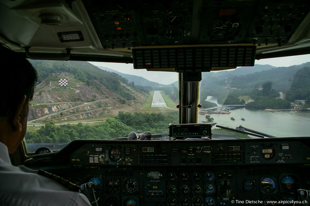
This is not how a straight in approach to Seletar is supposed to look like

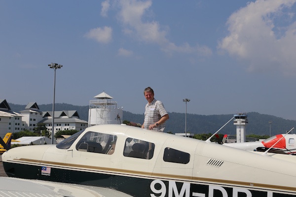
As the saying goes, pilots start off with a ton of luck and no experience and hope to gain enough experience before their luck runs out. I used up a good portion of luck and learned a lot of things yesterday.

On my way back from Kota Bahru, an uneventful three hour cross-country flight was crowned by one and a half hour of the most challenging and scary flying I have ever done.

Within 30 minutes, a couple of rapidly growing and fast moving thunderstorms put Johor, Seletar, Subang and Tioman into IMC – all at the same time.

Mind you, I am not talking about a bit of bad visibility that is crappier than what we normally deal with in South East Asia. I am talking about the big black impenetrable blanket that cover large junks of the land.

While orbiting next to one of those monsters my ground speed in one 360 degree turn varied by 70 knots! The aircraft was going up and down so rapidly that the AP disengaged, my headset flew off and I banged my head into the ceiling so badly hat I saw stars in the clouds. (Advice from the “Been there, done it” department : truly tighten the seat belts and do not just chant this point on the check list. )

If you know the layout of the airports in Malaysia, you will also know that there was literally no viable option to land anymore and I was at the end of a 3 hour flight with about 2 hours endurance left if I would have flown the tanks empty.

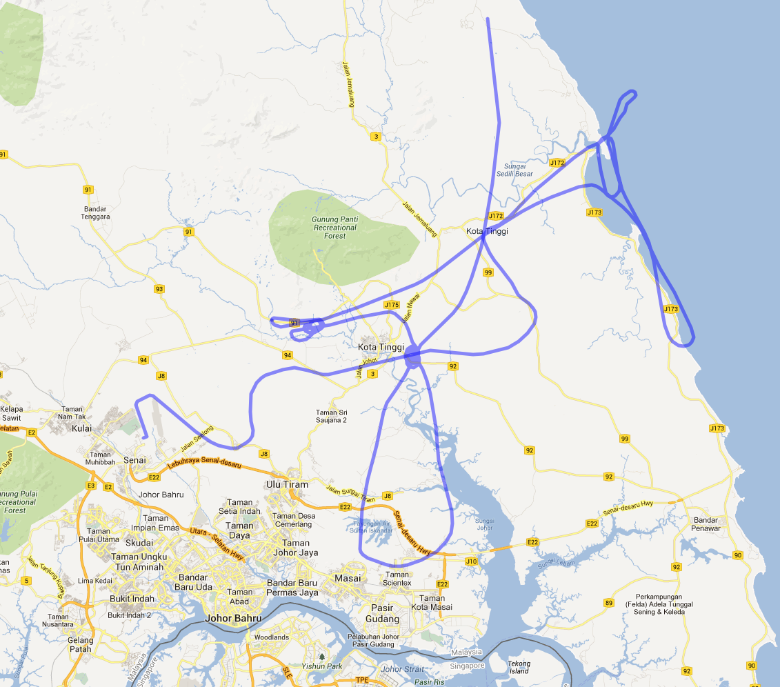
So I was flying up and down the East coast between Sidilli Besar and Desaru to find an opening, but every time I thought I had found something, ATC told me that the weather radar looks even worth where unwanted to go.

Eventually, ATC negotiated with Singapore a 4000 feet climb and track to VJB, which is the VOR station there. With the up- and down-drafts yanking me around like mad I even had problems to remember what a VOR was, let alone how to track to one. However, many hours of lonely flying in my new airplane with plenty of time to play around with the avionics paid off.

I managed to go in the right direction, but lost my nerves close to Kota Tinggi, where I descended to 1000 feet again to track the ground.

Again, many flights to Mersing in the past gave me the confidence to navigate by ground features alone. I was even able to identify the danger areas by the the change in vegetation, but why I bothered to avoid the areas when I thought I might not make it to the airfield is one of those mysteries…

Finally I had the airfield in sight and what a beautiful sight it was! I guess this put me into such a calm and relaxed Zen state that I did one of my best landings ever – an absolute greaser. (Good landings only happen when nobody else is in the aircraft to witness it. But whether you believe me or not, I know what I saw… Or maybe my butt was just desensitized. )

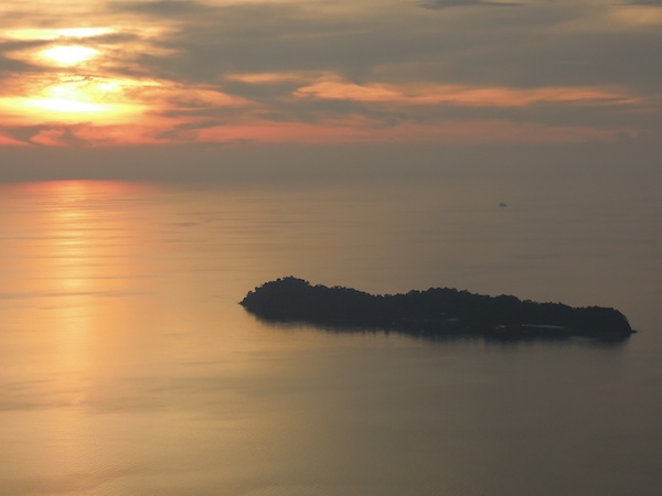
After big thunderstorms the view is often gorgeous, with unlimited visibility and haze rising out of the jungle in columns. And that was the sight Mother Nature greeted me with on my flight from Johor to Seletar in cool air and just the slightest drizzle. Maybe it was an apology for her earlier misfits?

Two Countries in Ten Minutes

In Flight Bag, Knowledge, Navigation on April 7, 2013 at 9:55 pm

9M-DRJ in its parking spot at Seletar Airport (Compact Parking A2)

5 April 2014: Note that for flights between Seletar and Senai airport the first reporting point in Malaysia after Point X-Ray is not the small hill (East of JB town) anymore.  The new reporting points are now Tebrau City Mall and Felda Ulu Tebrau. I have updated my VFR reporting point files (click here)  and you can also have a preview on Google Maps (click here).

1 May 2013: Updated the process to file general declaration forms for departure.  It is now necessary to bring three GenDex forms to the Apron office.  Apron will keep two forms and hand back the third one with a big stamp on it that proves you have paid the passenger fee or that you do not have passengers.  The GenDex with the stamp need to be handed to the immigration officer.

Since I started to fly 9M-DRJ, which has a parking space in Singapore, Seletar airport, I routinely fly between Singapore and Johor.  The flight is very short (15 to 20 minutes) and I think it is pretty cool that you can hop over to Johor for a quick chat any time you want to.  Of course, flying to any other place in Malaysia is also more convenient.  The immigration and customs control in Seletar is very fast, friendly and efficient.  From leaving home (East Coast) to taking off can be accomplished in less than an hour.

Before I started flying from Seletar I heard stories about inflexible ATC procedures, but I have not experienced this.  Of course, safety is paramount, but within the confines of the procedures Seletar tower is very accommodating and flexible.  If they can make it happen without compromising security they will.  Just asked nicely and with proper radio protocol and you will be fine!

I only know ground operations West of the runway. The assumption in my post is that you will fly between Seletar and Senai airport. For Tioman and other directions over the Malaysian peninsular, just change the reporting points after “East of JB Town”.

Read the rest of this entry »

VFR Reporting Points

In Flight Bag, Navigation on February 10, 2013 at 10:33 pm

VFR Reporting Points on the Malaysian Peninsula

28 April 2013: Added waypoints along the east coast and two routes from KL to Kota Bahru.

In Malaysia ATC follows all VFR flights regardless of the classification of the airspace and pilots must submit a flight plan for all VFR cross-country flights.  This practice requires some common understanding of acceptable reporting points between VFR pilots and ATC.  Given the importance of reporting points for VFR flying in Malaysia, there is surprisingly little information and documentation about them.  As I have written in my post about the availability of aviation charts, there is no such thing as up-to-date sectional charts that could be used for flight planning and pilotage navigation.  for small parts of the airspace (Langkawi, Johor, Tioman, KL) I have tried to rectify this by drawing my own maps, but this is a very poor replacement for proper charts.

In addition to drawing my own charts, I have also collected reporting points I have used in my cross-country flying.  And with this post, I am going to share this information (download different versions here V1 V2 V3 V4 V5).  Most pilots own GPS devices and use them for navigational purposes.  Some devices or applications on the iPad or iPhone can import geographical points in certain formats, so I am providing the data in GPX format as well.  I am able to convert this file into other formats, so if you tell me what you need, I may be able to help.  I would certainly be interested in hearing if you have been successful in using the file with your GPS device or application.  I do know for certain that the file can be imported into Google Maps and into the MotionX GPS application on the iPad and iPhone.

Read the rest of this entry »

West coast weekend flying

In Flight Log, Navigation on December 4, 2012 at 6:22 pm
Sunset over Pulau Paya

Sunset over Pulau Paya

Flight Summary
Engine Time 14h 43m
Landings 8
Fuel total 94 Gallons
Fuel per hour approx. 7 Gallons (26.5 Liters)
Hotel cost approx. RM 700 (SGD 280)
Pictures Click here

The trip from Johor to Langkawi presented most of its challenges while we were on the ground than being in the air.  In Johor the fuel bowser was broken, in Subang we arrived at an unfortunate time (lunch) and in Penang the fuel truck wouldn’t start.  Thankfully the weather was on our side and we made it to Langkawi despite all the delays.  For our troubles, mother nature rewarded us with a gorgeous sunset over Langkawi. With the last rays of sunshine we just about made into Langkawi airport around 19:00.

Read the rest of this entry »

Where the wind will carry me …

In Flight Log, Navigation on October 13, 2012 at 2:24 pm
Flight Summary
Engine Time 11h 51m
Landings 7
Fuel total 85 Gallons
Fuel per hour approx. 7.2 Gallons (28 Liters)
Hotel cost approx. RM 240 (SGD 100)
Pictures Click here

The flight safari has been postponed, so I had free time on my hand and decided to jump into the club piper to see where the wind would carry me.

13 October 2012, 14:00 LT, Malacca Airport

Empty Airport Terminal in Malacca

Well, as it turns out the wind decided to carry me exactly 100 nm before putting a full stop on my plans with thunderstorms over Subang. Now I am sitting in an empty airport terminal in Malacca and hope I will later make it to Penang and Langkawi.

Read the rest of this entry »