Ingo Noka

Posts Tagged ‘flight plan’

Thailand – Live Updates

In Flight Log, Navigation on July 26, 2013 at 11:35 pm

9MDRJ Refuel Stop

I am ready to go.  Flight plans are filed, bag is packed and lots of paper printed out in the hope that I will find the information when I need it.

Live Updates will appear on Facebook and Twitter  and I will attempt to post a summary of my exploits every day, but cannot guarantee I will have enough energy left in the evening.

If the weather is VMC at Seletar tomorrow morning, I will try to take of by 7:30 am, so that I can be in Penang before noon and in Hat Yai by 2 pm.

First fuel stop is Penang, but I am not going to fill up to the top, because I have to buy fuel in Hat Yay in 100L increments.  I am hoping they will keep the fuel I don’t need tomorrow for two days, so that I do not waste too much fuel.

Pulau Redang Revisited

In Knowledge, Navigation on June 25, 2013 at 12:15 pm

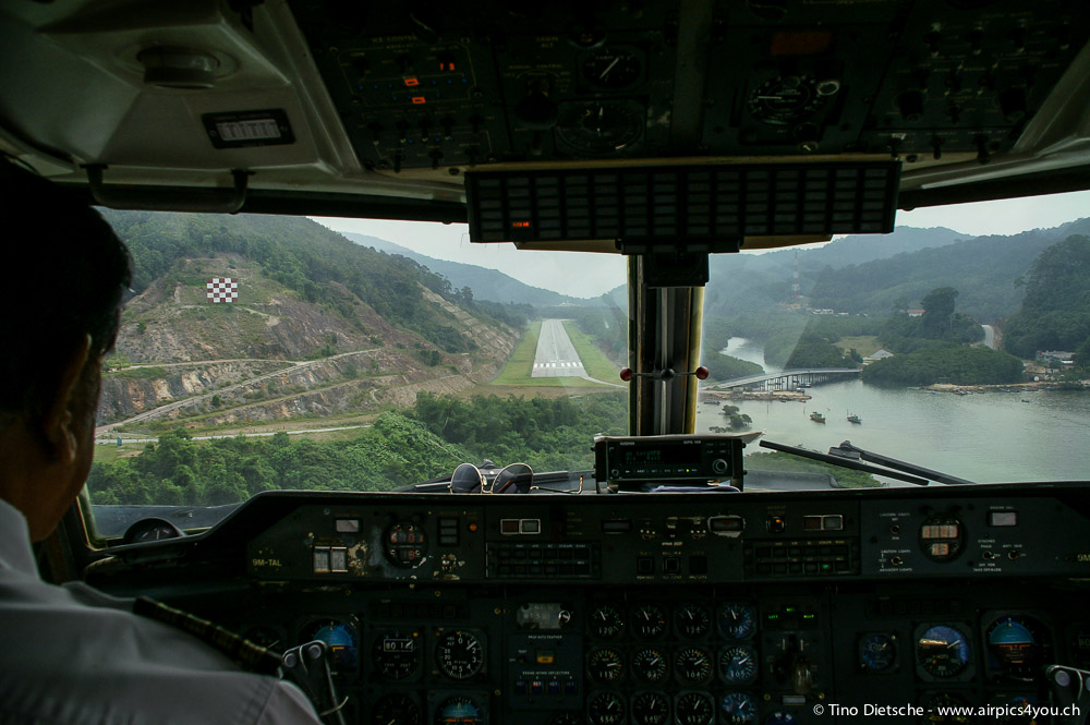
Berjaya Air – Approach to Pulau Redang (Copyright Tino Dietsche)

Pulau Redang is a small island off the East Coast of Malaysia. It has a small runway and is a favorite flying destination for many pilots from Singapore or Malaysia. As with many of these small airports, the problem is Avgas supply and immigration facilities.

One of the WoA pilots stopped over at Pulau Redang on our way back from the APFT Air Carnival and he was kind enough to send me some new information about the procedures at Pulau Redang. (I had written earlier about Redang in this post.)

Avgas is obviously not available on the island. In fact, Petronas does not offer Avgas anywhere along the East coast. However, APFT, based at Kota Bahru and Terengganu assured us that they would be happy to sell Avgas at both locations as long as we tell them in advance. I have the contact details, but do not want publish them here. Feel free to contact me, if you want to get in touch with them.

One option to complete the immigration and customs formalities would be to stop at Senai Airport (for the Singapore crowd) or to do it at Kota Bahru. I am not so sure about Terengganu, but I have done it at Kota Bahru. However, you need to check whether they are open, because immigration is only around when international flights depart or arrive.

The much better option is to do the immigration and customs on Pulau Redang. The immigration officer is around whenever a Berjaya Air flight is arriving and departing. At all other times you will have to inform them of your ETA. You should use this form and fax it directly to the airport manager Mr. Fendi. In any case, you will have to arrive between 8 am and 5 pm local time.

Your aircraft can be parked over night at the airport. With the aircraft tail hanging over the edge, there should be space for a maximum of three small planes. Parking is free for the first three hours, How much it is thereafter I don’t know. I know however that the landing charge is Ringgit 15.50.

Well, there it is. I hope this helps a bit. Please let me know if you have information about any of the other flying destinations in South East Asia.

(BTW: The title picture was taken by Tino Dietsche who graciously let me use it on my blog. He has written a nice article on his flight to Redang here.)

Flight Plans in Malaysia

In Flight Bag, Knowledge, Navigation on June 16, 2013 at 10:54 am

DCA Tower Penang

The Malaysian ATC expects you to file a flight plan for all VFR flights, unless you just stay in the training areas or do a few circuits to practice your landings.

Most pilots will fill in a flight plan form on paper and fax it to the ATC unit of the departure airport. ATC will forward the FPL using the usual data exchange network. That means most of the formatting will be done by the controller and the pilot does not really need to know much about the FPL message formats.

As soon as you are crossing borders, this changes, however. Suddenly you are confronted with the need to send your flight plan to all control units along your proposed route and you have to be careful with the formatting and completeness of your flight plan message.

I have found two flight plan filing systems that work very well for me. The first one is a web based system from the UK, which is available under www.eurofpl.eu. The second one is a Java application that is provided by the Singapore CAAS.

All three methods (fax, web, application) have their benefits and issues. I personally prefer the web-based system, followed by the Java application and finally the fax.

I usually combine the fax method with an online fax application called eFax. With my iPhone acting as a personal hotspot for my laptop, I am able to fax flight plans from anywhere, including the parking apron.

In my next posts on this topic, I’ll give you an overview of how the three methods work and how flight plan messages are formatted in general.

VFR Reporting Points

In Flight Bag, Navigation on February 10, 2013 at 10:33 pm

VFR Reporting Points on the Malaysian Peninsula

28 April 2013: Added waypoints along the east coast and two routes from KL to Kota Bahru.

In Malaysia ATC follows all VFR flights regardless of the classification of the airspace and pilots must submit a flight plan for all VFR cross-country flights.  This practice requires some common understanding of acceptable reporting points between VFR pilots and ATC.  Given the importance of reporting points for VFR flying in Malaysia, there is surprisingly little information and documentation about them.  As I have written in my post about the availability of aviation charts, there is no such thing as up-to-date sectional charts that could be used for flight planning and pilotage navigation.  for small parts of the airspace (Langkawi, Johor, Tioman, KL) I have tried to rectify this by drawing my own maps, but this is a very poor replacement for proper charts.

In addition to drawing my own charts, I have also collected reporting points I have used in my cross-country flying.  And with this post, I am going to share this information (download different versions here V1 V2 V3 V4 V5).  Most pilots own GPS devices and use them for navigational purposes.  Some devices or applications on the iPad or iPhone can import geographical points in certain formats, so I am providing the data in GPX format as well.  I am able to convert this file into other formats, so if you tell me what you need, I may be able to help.  I would certainly be interested in hearing if you have been successful in using the file with your GPS device or application.  I do know for certain that the file can be imported into Google Maps and into the MotionX GPS application on the iPad and iPhone.

Read the rest of this entry »

Where the wind will carry me …

In Flight Log, Navigation on October 13, 2012 at 2:24 pm
Flight Summary
Engine Time 11h 51m
Landings 7
Fuel total 85 Gallons
Fuel per hour approx. 7.2 Gallons (28 Liters)
Hotel cost approx. RM 240 (SGD 100)
Pictures Click here

The flight safari has been postponed, so I had free time on my hand and decided to jump into the club piper to see where the wind would carry me.

13 October 2012, 14:00 LT, Malacca Airport

Empty Airport Terminal in Malacca

Well, as it turns out the wind decided to carry me exactly 100 nm before putting a full stop on my plans with thunderstorms over Subang. Now I am sitting in an empty airport terminal in Malacca and hope I will later make it to Penang and Langkawi.

Read the rest of this entry »

Watch your Weights

In Airmanship, Flight Bag, Knowledge on September 18, 2012 at 12:13 am

This pilot has become rather heavy. Time to brush up on W&B!

During our flight training we have all learned how to do the weight and balance calculations and we have been told that this is something we must do before every flight.  Of course, even then, many of us thought this exercise was only good for watching the instructor’s reaction when you filled in his weight (for the examiner your estimate better had to be on the low side).

For me this was the state of affairs for the first 100 hours of my PPL “career”.  However, lately I am flying more and more with passengers and luggage, so I thought I’d better brush up on my W&B knowledge. As things go these days, my first thought was whether there is an App for that, and sure enough there are plenty.  In one of my next posts I will review an excellent application from Angell Development LLC by the name of WnB Pro.

Let’s talk first about the theory of W & B.  As usual the FAA has very good materials on their web site (Aircraft Weight and Balance Handbook, FAA-H-8083-1A).  I recommend reading this document if you are really serious about this stuff.

Read the rest of this entry »

Langkawi – All you need to know

In Flight Bag, Navigation on July 6, 2012 at 11:13 pm

Langkawi VFR Map

When I came back from my “Round Malaysia” trip, I promised that I would post what I had learned about the reporting points for a Langkawi island tour.

This got a bit delayed, but now I have finished a map of Langkawi, which I think contains everything a pilot needs to know for a flight to and around Langkawi.

Read the rest of this entry »

Have a look at Pulau Rawa

In Flight Log, Navigation on February 27, 2012 at 12:07 am

Flight Log Pulau Rawa on 26 February 2012

Today I went to Pulau Rawa (a little island East of Mersing) and since I have now done it twice, I thought I would give some advice to fellow pilots who want to fly this beautiful VFR route.

Some basic information about this route:

  • Distance: 144 nm
  • Realistic time with about 5 to 10 minutes over Pulau Rawa: 1 hour 55 minutes
  • AT4 fuel usage: 38 liters
  • Flight log: download link (Apple Pages Format, this link is not going to be updated!)
  • Flight plan: download link (Apple Pages Format, this link is not going to be updated!)

Read the rest of this entry »

Better Scale

In Flight Bag, Gear on February 12, 2012 at 9:11 pm

Johor Airspace Map

I have updated my “chart” and trimmed it down to A4.  I have also attempted to scale it properly at 1:500,000 (i.e. the Sectional Chart scale).  The actual scale of the printed map depends very much on the printer.  The idea is to print the map on A4 without any resizing.  On my Macbook Pro it works very well with paper size A4 and a scale of 100% (in the printer dialog).

BTW: I have created these maps with Inkscape using an old TPC chart and a couple of other free resources from the Internet.  The maps are available in the source format (SVG), which can be opened with Inkscape and other vector graphic programs.  The other formats are in bitmap formats (JPEG, PNG and PDF) and cannot be edited in the sense that elements of the charts are just bitmaps and cannot be changed in shape etc.

The maps can be downloaded here.

All Well with Port Weld

In Flight Bag on January 29, 2012 at 10:58 pm

Frederic Weld (1823-1891)

Finally the mystery of reporting point Port Well has been resolved.  We know where Port Well is, in fact we know Port Well does not exist.  If it ever existed it would have been Port Weld, which is a name that is not used anymore.  The actual name is Kuala Sepetang, and it must have been that way for quite some time, considering that our 40 years old maps already use it.  ATC in Malaysia is certainly not changing things around in a rush.

For over a year the fearless aviators of the FRAS flying club had to rely on wild guesses to determine where this reporting point “Port Well” might be.  ATC surely never explained it and no map or AIP document mentions the place.  Nevertheless, without fail, Lumpur Info or Ipoh tower would ask for a report at Port Well.  Until now, our chief flight instructor Captain Singh (Kevin Muk got a job that does not allow him to fly anymore) determined that Port Well must be somewhere between Pantai Remis and Bagan Serai, probably at the border of the Ipoh TMA. Read the rest of this entry »